- Statutory Instrument 1999 No. 1126
The Scottish Adjacent Waters Boundaries Order 1999
© Crown Copyright 1999
Statutory Instruments printed from this website are printed under the superintendence and authority of the Controller of HMSO being the Queen's Printer of Acts of Parliament.
The legislation contained on this web site is subject to Crown Copyright protection. It may be reproduced free of charge provided that it is reproduced accurately and that the source and copyright status of the material is made evident to users.
It should be noted that the right to reproduce the text of Statutory Instruments does not extend to the Queen's Printer imprints which should be removed from any copies of the Statutory Instrument which are issued or made available to the public. This includes reproduction of the Statutory Instrument on the Internet and on intranet sites. The Royal Arms may be reproduced only where they are an integral part of the original document.
The text of this Internet version of the Statutory Instrument which is published by the Queen's Printer of Acts of Parliament has been prepared to reflect the text as it was Made. A print version is also available and is published by The Stationery Office Limited as the The Scottish Adjacent Waters Boundaries Order 1999 , ISBN 0 11 059052 X. The print version may be purchased by clicking here. Braille copies of this Statutory Instrument can also be purchased at the same price as the print edition by contacting TSO Customer Services on 0870 600 5522 or e-mail:[email protected].
Further information about the publication of legislation on this website can be found by referring to the Frequently Asked Questions.
To ensure fast access over slow connections, large documents have been segmented into "chunks". Where you see a "continue" button at the bottom of the page of text, this indicates that there is another chunk of text available.
![]()
| Made | 13th April 1999 | ||
| Coming into force in accordance with article 1 |
Whereas a draft of this Order has been laid before, and approved by a resolution of, each House of Parliament in accordance with section 115(1) of, and paragraphs 1 and 2 of Schedule 7 to, the Scotland Act 1998[1];
Now, therefore, Her Majesty, in exercise of the powers conferred upon Her by section 126(2) of the Scotland Act 1998 is pleased, by and with the advice of Her Privy Council, to order, and it is hereby ordered, as follows:
Citation and commencement
1. This Order may be cited as the Scottish Adjacent Waters Boundaries Order 1999 and shall come into force on the principal appointed day[2].
Interpretation
2. In this Order-
-
"co-ordinate" means a co-ordinate on the Ordnance Survey of Great Britain 1936 Datum;
-
"line", in relation to any list of co-ordinates in this Order, means a loxodromic line.
Boundaries - internal waters and territorial sea
3.
For the purposes of the Scotland Act 1998, the boundaries between waters which are to be treated as internal waters or territorial sea of the United Kingdom adjacent to Scotland and those which are not, shall be-
Boundaries - sea within British fishery limits
4.
For the purposes of the Scotland Act 1998, the boundaries between waters which are to be treated as sea within British fishery limits adjacent to Scotland and those which are not, shall be-
A. K. Galloway
Clerk of the Privy Council
| 1. | 55° 48' 42"N | 02° 01' 54"W |
| 2. | 55° 49' 47"N | 01° 59' 58"W |
| 3. | 55° 50' 40"N | 01° 58' 09"W |
| 4. | 55° 50' 44"N | 01° 57' 55"W |
| 5. | 55° 53' 17"N | 01° 48' 28"W |
| 6. | 55° 53' 27"N | 01° 47' 54"W |
| 7. | 55° 55' 01"N | 01° 43' 32"W |
Solway Firth
| 1. | 54° 59' 05"N | 03° 03' 33"W |
| 2. | 54° 58' 18"N | 03° 04' 55"W |
| 3. | 54° 56' 59"N | 03° 08' 29"W |
| 4. | 54° 57' 41"N | 03° 10' 58"W |
| 5. | 54° 57' 39"N | 03° 14' 05"W |
| 6. | 54° 56' 22"N | 03° 20' 48"W |
| 7. | 54° 54' 34"N | 03° 27' 55"W |
| 8. | 54° 49' 11"N | 03° 32' 23"W |
| 9. | 54° 46' 44"N | 03° 38' 12"W |
| 10. | 54° 37' 50"N | 03° 50' 47"W |
Irish Sea
| 11. | 54° 37' 33"N | 03° 51' 05"W |
| 12. | 54° 36' 56"N | 03° 52' 05"W |
| 13. | 54° 36' 07"N | 03° 53' 52"W |
| 14. | 54° 33' 13"N | 04° 00' 11"W |
| 15. | 54° 32' 47"N | 04° 01' 07"W |
| 16. | 54° 31' 51"N | 04° 03' 09"W |
| 17. | 54° 30' 00"N | 04° 04' 25"W |
| 18. | 54° 30' 55"N | 04° 05' 39"W |
| 19. | 54° 33' 02"N | 04° 09' 08"W |
| 20. | 54° 33' 08"N | 04° 10' 35"W |
| 21. | 54° 33' 12"N | 04° 11' 42"W |
| 22. | 54° 33' 07"N | 04° 15' 26"W |
| 23. | 54° 33' 03"N | 04° 17' 30"W |
| 24. | 54° 32' 47"N | 04° 23' 57"W |
| 25. | 54° 32' 31"N | 04° 26' 12"W |
| 26. | 54° 32' 02"N | 04° 29' 24"W |
| 27. | 54° 31' 46"N | 04° 31' 53"W |
| 28. | 54° 31' 10"N | 04° 34' 49"W |
| 29. | 54° 30' 45"N | 04° 36' 48"W |
| 30. | 54° 29' 58"N | 04° 40' 17"W |
| 31. | 54° 29' 01"N | 04° 43' 37"W |
| 32. | 54° 27' 43"N | 04° 47' 32"W |
| 33. | 54° 26' 02"N | 04° 52' 02"W |
| 34. | 54° 27' 52"N | 05° 04' 36"W |
| 35. | 54° 28' 13"N | 05° 05' 08"W |
| 36. | 54° 30' 37"N | 05° 07' 18"W |
| 37. | 54° 31' 56"N | 05° 08' 37"W |
| 38. | 54° 32' 15"N | 05° 08' 57"W |
| 39. | 54° 33' 57"N | 05° 10' 50"W |
| 40. | 54° 36' 22"N | 05° 12' 41"W |
| 41. | 54° 38' 13"N | 05° 13' 43"W |
| 42. | 54° 38' 27"N | 05° 13' 44"W |
North Channel
| 43. | 54° 39' 48"N | 05° 14' 37"W |
| 44. | 54° 40' 39"N | 05° 14' 33"W |
| 45. | 54° 41' 49"N | 05° 14' 49"W |
| 46. | 54° 42' 02"N | 05° 14' 53"W |
| 47. | 54° 42' 50"N | 05° 15' 33"W |
| 48. | 54° 44' 08"N | 05° 16' 48"W |
| 49. | 54° 44' 58"N | 05° 17' 37"W |
| 50. | 54° 46' 37"N | 05° 19' 38"W |
| 51. | 54° 48' 21"N | 05° 21' 50"W |
| 52. | 54° 49' 29"N | 05° 23' 21"W |
| 53. | 54° 49' 51"N | 05° 23' 48"W |
| 54. | 54° 50' 05"N | 05° 24' 11"W |
| 55. | 54° 50' 40"N | 05° 25' 05"W |
| 56. | 54° 51' 22"N | 05° 26' 05"W |
| 57. | 54° 51' 25"N | 05° 26' 08"W |
| 58. | 54° 51' 57"N | 05° 26' 28"W |
| 59. | 54° 52' 40"N | 05° 26' 51"W |
| 60. | 54° 53' 10"N | 05° 27' 07"W |
| 61. | 54° 53' 53"N | 05° 27' 24"W |
| 62. | 54° 54' 19"N | 05° 27' 23"W |
| 63. | 54° 54' 54"N | 05° 27' 44"W |
| 64. | 54° 55' 44"N | 05° 28' 21"W |
| 65. | 54° 55' 59"N | 05° 28' 32"W |
| 66. | 54° 56' 49"N | 05° 29' 13"W |
| 67. | 54° 57' 31"N | 05° 29' 53"W |
| 68. | 54° 57' 53"N | 05° 30' 10"W |
| 69. | 54° 58' 53"N | 05° 31' 05"W |
| 70. | 54° 59' 45"N | 05° 32' 00"W |
| 71. | 55° 00' 31"N | 05° 32' 58"W |
| 72. | 55° 01' 22"N | 05° 34' 12"W |
| 73. | 55° 02' 08"N | 05° 35' 29"W |
| 74. | 55° 02' 48"N | 05° 36' 47"W |
| 75. | 55° 03' 25"N | 05° 38' 13"W |
| 76. | 55° 04' 01"N | 05° 39' 47"W |
| 77. | 55° 04' 29"N | 05° 41' 15"W |
| 78. | 55° 04' 55"N | 05° 42' 53"W |
| 79. | 55° 05' 15"N | 05° 44' 21"W |
| 80. | 55° 05' 30"N | 05° 44' 37"W |
| 81. | 55° 06' 25"N | 05° 45' 46"W |
| 82. | 55° 07' 13"N | 05° 46' 51"W |
| 83. | 55° 08' 05"N | 05° 48' 13"W |
| 84. | 55° 08' 21"N | 05° 48' 41"W |
| 85. | 55° 08' 53"N | 05° 49' 03"W |
| 86. | 55° 09' 57"N | 05° 49' 54"W |
| 87. | 55° 10' 58"N | 05° 50' 50"W |
| 88. | 55° 11' 53"N | 05° 51' 50"W |
| 89. | 55° 12' 41"N | 05° 52' 48"W |
| 90. | 55° 12' 57"N | 05° 53' 11"W |
| 91. | 55° 13' 12"N | 05° 53' 33"W |
| 92. | 55° 13' 46"N | 05° 54' 29"W |
| 93. | 55° 14' 20"N | 05° 55' 08"W |
| 94. | 55° 14' 33"N | 05° 55' 25"W |
| 95. | 55° 15' 04"N | 05° 56' 10"W |
| 96. | 55° 15' 20"N | 05° 56' 35"W |
| 97. | 55° 15' 46"N | 05° 57' 20"W |
| 98. | 55° 16' 07"N | 05° 58' 02"W |
| 99. | 55° 16' 32"N | 05° 58' 56"W |
| 100. | 55° 16' 47"N | 05° 59' 32"W |
| 101. | 55° 17' 03"N | 06° 00' 15"W |
| 102. | 55° 17' 08"N | 06° 00' 27"W |
| 103. | 55° 17' 37"N | 06° 00' 46"W |
| 104. | 55° 18' 16"N | 06° 01' 16"W |
| 105. | 55° 18' 41"N | 06° 01' 38"W |
| 106. | 55° 19' 08"N | 06° 02' 04"W |
| 107. | 55° 19' 10"N | 06° 02' 07"W |
| 108. | 55° 19' 36"N | 06° 02' 34"W |
| 109. | 55° 20' 11"N | 06° 03' 18"W |
| 110. | 55° 20' 15"N | 06° 03' 24"W |
| 111. | 55° 20' 32"N | 06° 03' 47"W |
| 112. | 55° 20' 56"N | 06° 04' 25"W |
| 113. | 55° 21' 16"N | 06° 05' 02"W |
| 114. | 55° 21' 43"N | 06° 05' 57"W |
| 115. | 55° 22' 00"N | 06° 06' 34"W |
| 116. | 55° 22' 07"N | 06° 06' 54"W |
| 117. | 55° 22' 18"N | 06° 07' 22"W |
| 118. | 55° 22' 33"N | 06° 08' 06"W |
| 119. | 55° 22' 45"N | 06° 08' 45"W |
| 120. | 55° 22' 55"N | 06° 09' 12"W |
| 121. | 55° 23' 09"N | 06° 09' 53"W |
| 122. | 55° 23' 22"N | 06° 10' 40"W |
| 123. | 55° 23' 31"N | 06° 11' 13"W |
| 124. | 55° 23' 39"N | 06° 11' 38"W |
| 125. | 55° 23' 59"N | 06° 12' 41"W |
| 126. | 55° 24' 09"N | 06° 13' 16"W |
| 127. | 55° 24' 24"N | 06° 14' 19"W |
| 128. | 55° 24' 26"N | 06° 14' 24"W |
| 129. | 55° 24' 37"N | 06° 15' 16"W |
| 130. | 55° 24' 47"N | 06° 16' 12"W |
| 131. | 55° 24' 49"N | 06° 16' 23"W |
| 132. | 55° 24' 59"N | 06° 17' 16"W |
| 133. | 55° 25' 09"N | 06° 18' 18"W |
| 134. | 55° 25' 16"N | 06° 19' 12"W |
| 135. | 55° 25' 25"N | 06° 20' 28"W |
| 136. | 55° 25' 33"N | 06° 21' 58"W |
| 137. | 55° 25' 35"N | 06° 22' 34"W |
| 138. | 55° 25' 36"N | 06° 22' 53"W |
| 139. | 55° 25' 41"N | 06° 23' 57"W |
| 140. | 55° 25' 44"N | 06° 24' 54"W |
| 141. | 55° 25' 48"N | 06° 26' 52"W |
| 142. | 55° 25' 49"N | 06° 27' 39"W |
| 143. | 55° 25' 49"N | 06° 28' 39"W |
| 144. | 55° 25' 48"N | 06° 29' 56"W |
| 145. | 55° 25' 51"N | 06° 30' 11"W |
| 146. | 55° 25' 54"N | 06° 30' 25"W |
| 147. | 55° 26' 05"N | 06° 31' 23"W |
| 148. | 55° 26' 14"N | 06° 32' 11"W |
| 149. | 55° 26' 22"N | 06° 32' 57"W |
| 150. | 55° 26' 34"N | 06° 34' 15"W |
| 151. | 55° 26' 37"N | 06° 34' 40"W |
| 1. | 55° 55' 01'N | 01° 43' 32'W |
| 2. | 55° 56' 00'N | 01° 40' 35'W |
| 3. | 55° 56' 30'N | 01° 38' 54'W |
| 4. | 55° 58' 01'N | 01° 33' 49'W |
| 5. | 56° 01' 54'N | 01° 26' 02'W |
| 6. | 56° 11' 41'N | 01° 11' 20'W |
| 7. | 56° 22' 16'N | 00° 55' 04'W |
| 8. | 56° 23' 39'N | 00° 50' 28'W |
| 9. | 56° 27' 10'N | 00° 38' 41'W |
| 10. | 56° 27' 40'N | 00° 35' 11'W |
| 11. | 56° 30' 12'N | 00° 17' 09'W |
| 12. | 56° 32' 41'N | 00° 01' 51'E |
| 13. | 56° 33' 38'N | 00° 13' 13'E |
| 14. | 56° 34' 39'N | 00° 26' 10'E |
| 15. | 56° 36' 13'N | 00° 47' 53'E |
| 16. | 56° 36' 26'N | 00° 57' 24'E |
| 17. | 56° 36' 32'N | 01° 10' 34'E |
| 18. | 56° 36' 37'N | 01° 30' 00'E |
| 19. | 56° 36' 39'N | 02° 00' 00'E |
| 20. | 56° 36' 33'N | 02° 30' 00'E |
| 21. | 56° 36' 31'N | 02° 36' 26'E |
(This note is not part of the Order)
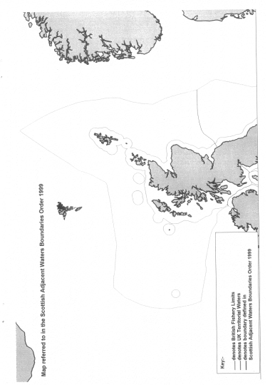
This Order describes for the purposes of the Scotland Act 1998-
-
(a) the boundaries between waters which are to be treated as internal waters or territorial sea of the United Kingdom adjacent to Scotland and those which are not (article 3) and
(b) the boundaries between waters which are to be treated as sea within British fishery limits adjacent to Scotland and those which are not (article 4).
A map showing the line of the boundaries for illustrative purposes only is appended to this note.
Map
Notes:
[1] 1998 c.46.back
[2] The pricipal appointed day is 1st July 1999 by virtue of article 3 of the Scotland Act 1998 (Commencement) Order 1998 (S.I. 1998/3178)back
ISBN 0 11 059052 X